Preferences
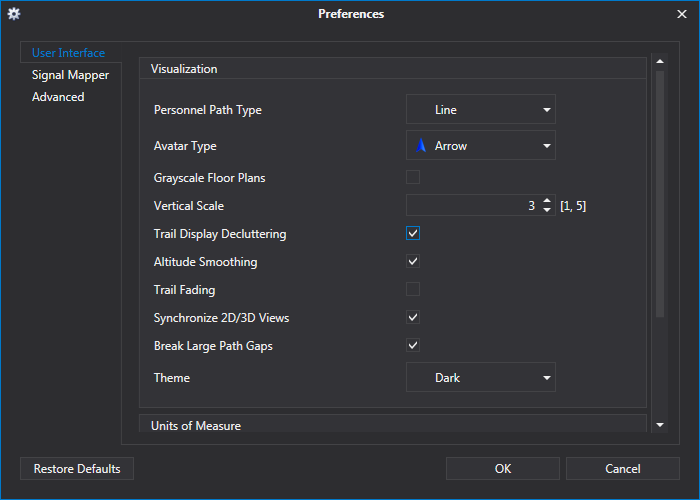
NEON Command is equipped with a few preferences to help users customize their experience. These preferences allow users to configure the user interface, signal map capabilities, and load custom map sources. To restore preferences to the TRX Systems defaults, click the “Restore Defaults” button in the bottom left of the preferences window.

The sections below describe each of the preferences that can be changed in each of the tabs found on the left side of the preferences window. Possible settings are shown in brackets next to the name of the preference. If there are no settings listed, the preference can be either enabled or disabled.
User Interface
Visualization
- Personnel Path Type [Point, Line] - Changes the appearance of paths.
- Avatar Type [Arrow, Person, Compass] - Changes the avatars used to represent personnel.
- Grayscale Floorplans - This will convert floor plans with color to grayscale to help with viewing heatmaps.
- Vertical Scale [1 - 5] - Set the vertical scale multiplier. Buildings and terrain will appear taller at higher values.
- Trail Display Decluttering - Hides path segments from when a user previously visited the floor they are currently on.
- Altitude Smoothing - Smooths out minor bumps in paths that may be caused by tiny pressure fluctuations or steps.
- Trail Fading - Causes the path to fade behind the avatar.
- Synchronize 2D/3D Views - Synchronizes the zoom level of 2D and 3D views.
- Break Large Path Gaps - Hides the path between 2 adjacent points if they are more than 50 meters apart.
- Theme [Light, Dark] - Changes the appearance of NEON Command.
Units of Measure
- Length [Feet, Meters] - Changes the units for length measurements.
Playback
- Looping Enabled - Playback of signal maps or tracking history will restart after completion.
Signal Mapper
Heatmap Options
- Smoothing Radius (meters) [1.0, 20.0] - Controls how far the heatmap will spread from signal dots.
- Max Opacity (%) [0, 100] - Changes the opacity of the heatmap. Even at 100%, the heatmap will still fade to transparent at the edges.
- Aggregation Method [Max, Min, Average] - Sets which signal measurements are used to generate the heatmap. Heatmaps are binned aggregations of individual measurements. So if, for instance, there are 10 measurements in a 5x5 meter area, the color of the underlying heatmap will represent the min, max, or average of those 10 values. In addition, if the user stood still in an area and read 10 measurements, only one colored dot would be shown representing the min, max, or average of those 10 values. Clicking on the dot will show all 10 measurements at that location. The CSV export file will show every individual measurement - so the aggregation measurement only affects the visual display of the dots and heatmaps. Generally, max is the default because it will show you the highest signal strength received at each location. However, if requirements specify that the signal must always be above a certain level, then set it to min, and if requirements specify that the signal must on average be above a certain level, then set it to average.
Grid Testing
- Enable Grid Testing - Allows users to check if a building complies with NFPA building testing recommendations. Replaces standard color maps and overlays grids on floor plans.
- Pass/Fail Threshold (dBm) [-119, -1] - Sets the minimum required signal measurement (dBm) for a grid square to pass.
- Measurements Required in Grid (dBm) [1, 100] - Sets the required number of signal measurements for a grid square to pass or fail.
- Pass/Fail Threshold (DAQ) [1.1, 4.9] - Sets the minimum required DAQ measurement for a grid square to pass.
- Measurements Required in Grid (DAQ) [1, 10] - Sets the required number of DAQ measurements for a grid square to pass or fail.
Locate WiFi Access Point and BLE Nodes
- Signal Strength Display Threshold - Sets the minimum signal strength measurement needed to display an access point.
Color Map Options
- dBm Scale - Sets the default color scale to be used with dBm measurements.
- DAQ Scale - Sets the default color scale to be used with DAQ measurements.
NOTE: These settings can also be changed in the color map editor.
