Visualizer
The Signal Mapper Visualizer provides context for and displays signal data.
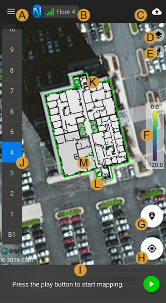
Each element in the visualizer is labeled in the image above:
A. The menu button opens up the navigation menu for the app. Go to Navigation Menu for more information.
B. The “Nav Lock” shows one to four bars that represent the capability of the NEON Location Service to maintain the current error bounds without any additional constraints (beacons, GPS, check-ins). It will also display the current tracking or connection status. Initialize to get a full “Nav Lock”. Visit Nav Lock Indicator for more information
C. The contextual menu for signal mapping. When not mapping, allows users to upload saved signal maps.
D. The “Layers” menu allows hiding or showing buildings, features, references, and signals.
E. The Compass icon shows north and can be tapped to reset a north up view.
F. The “Signal Scale” shows the color and signal strength mapping. A different color map can be selected from the Settings menu.
G. The “Check-In” icon drops a pin on the map that can be placed to correct the location of the user.
H. The “Center on Me” icon centers the map on the user’s location.
I. The Signal Tray provides information about the state of signal mapping and the signals that are being received. It provides instructions for initialization and allows control to start and stop the recording of signal map data.
J. The “Elevation” sidebar allows the user to select a floor in the building. The currently selected floor is highlighted in blue.
K. The building is displayed with a green outline when it is selected. It can be selected by tapping on the building shape. If a floor plan image has been added to NEON the floor plan is displayed.
L. The feature icons show structural features that have been added using the Building Editor in NEON Command.
M. The avatar is an icon that shows the position and direction that the user is facing. The avatar is green when the user is initialized and red when the user is not initialized. The avatar is a circle when the direction of the user is unknown. The error bound circle is displayed around the avatar and shows the level of uncertainty in the location.